
Bramcote: Past and Present
Glimpses can still be discerned of the Bramcote described in White’s Directory of 1844, as “One of the most delightful villages in the whole county; it is scaled upon several lofty hills, from which extensive and beautiful prospects are seen, and contains several handsome mansions occupied by their owners… comprises 732 inhabitants and about 1,000 acres of rich, sandy land.” Those glimpses are cherished and deserve to be conserved even if present day Bramcote is more “conveniently situated suburb” than “delightful village”.
Early History
The name Bramcote is thought to be Saxon in origin and mean “dwelling in the broom”, although Bronze Age burial urns were found here in 1978. Prior to the Norman Conquest, the main part of Bramcote was held by Danish Thegns; Ulchel, Godric, Levric and Alvric, who also had land elsewhere. The Domesday Book of 1086 provides the first mention of a village called Bruncote or Broncote in the Wapentake (administrative district) of Broxtowe with the Norman, William Hostiaurus (meaning the usher or porter) being the main landowner. During the Middle Ages, parts of Bramcote were in the hands of the Willoughbys of Wollaton and the convent of Gilbertines at Sempringham in Lincolnshire. After the Dissolution of the Monasteries the land was eventually acquired by the family of Hanley, passing subsequently to the Sherwin, Longden and Holden families.
Victorian Times
The agricultural nature of the village diminished during the first half of the nineteenth century as coal mining and domestic industry, such as framework knitting, became favoured occupations. Eventually competition from the factories meant that the villagers began to seek employment in Beeston and Stapleford or looked for positions in domestic service. Bramcote had become a popular place for wealthy business people to reside because of its rural nature and proximity to the city of Nottingham.
War and its effects
At the end of World War One, Bramcote mourned the loss of fit young men and families coped with the physical and mental frailties of those who returned, but this was also a real watershed in terms of the entire structure of village society. The latter day manor of Bramcote centred on Bramcote Hills House and encompassed much land and property across both Bramcote and Stapleford. Major Ernest Frank Holden decided to relinquish his assets and responsibilities locally and a major auction of land and properties took place in 1919. The mansion in the park survived as a tenanted property until it was requisitioned as a rehabilitation centre and hostel for A.T.S. drivers during World War Two, but subsequently became the subject of a compulsory purchase order.
The Second Elizabethan Era
The 1950s and 1960s saw huge changes in Bramcote as the housing, school and transport needs of the post-war generation were addressed. Certainly the most significant development was the establishment of the Bramcote Hills Housing Estate, but there were also changes in the heart of the village as older cottages, deemed unfit for human habitation, were demolished, and more suitable facilities offered on Hanley Avenue. Footpaths were constructed in the village, the A52 was widened following the compulsory purchase of gardens, and the creation of the Stapleford by-pass brought easier access to the motorway network.
The local county and urban district councils were the enforcers and suppliers of such changes – the clear successors to the Victorian benefactors who had come to live here. Few of their residences continued as Bramcote Neighbourhood Forum Page 10 of 48 29 August 2017 family homes but became hostels for university students in the case of The Grove and The White House, and offices and laboratories were established by the British Sugar Corporation at the Grange. Bramcote Hall was a preparatory school until 1965 but then sadly demolished, as was Bramcote Hills House – this was in the era before buildings were given listed status.
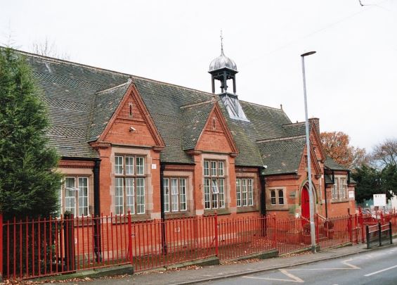
On a more positive note, the facilities provided on the 75 acre Bramcote Hills Schools campus were generally admired and parents were happy for their children to travel across the county to be schooled here. The addition of the swimming pool, opened in 1965, was welcomed too. “Bigger and better” might have been the motto of planners and entrepreneurs at that time and as the likes of the “Big D” DIY store and a frozen food centre appeared on the Hills Estate, so the small village shops and businesses closed their doors. The style of village activities and community ventures altered too. The annual garden parties, village shows, fashion parades etc. ceased to attract interest and many welfare groups manned by local women folded as women were legally allowed to continue in the work place after motherhood. Today the old school building, the old Roman Catholic Hall and the Memorial Hall are all places where pre-school care is offered.
Places adapt as society’s needs change and in Bramcote we are fortunate that local folk care about their environment and wish to protect their heritage. Broxtowe Borough Council acknowledged Bramcote’s attractions when, in 1970, it created its first Conservation Area here.
Residents are pleased that the vestiges of former times can be seen – from the terrace of framework knitters’ homes on Derby Road to the original seventeenth century Manor House on Toton Street; from the cottages that were once the premises of the butcher, the grocer, the post mistress etc. to a few surviving mansions of the local gentry as well as the places where local folk worshiped and were schooled in previous generations. As Bramcote continues to develop, it is vital to maintain that small nucleus of the past, even though it is so surrounded by red brick.
Environment and Ecology
Most of Bramcote lies above Triassic Sherwood Sandstone (formerly known as the Bunter Sandstone). North of Bramcote Ridge is a faulted contact with Coal Measures of the Carboniferous Period. The area’s typically sandy, acidic soils support the increasingly rare heathland habitat and oak / birch woodland indigenous to the Sherwood area (Broxtowe Nature Conservation Strategy). There are still large areas of “green space” which, despite being heavily managed, have allowed the habitat and its associated wildlife to become established. The sandstone ridge that runs through Stapleford to the west penetrates into Bramcote and links through towards Wollaton Park via the former golf course, the Alexandrina Plantation and the Sandy Lane Open Space.

